اصلوڪو فائيل (12,648 × 4,882 عڪسلون، فائيل سائيز: 18.75 MB، MIME ٽائيپ: image/jpeg)

ھي فائيل وڪيميڊيا العام مان آھي ۽ ٻين رٿائن پاران پڻ استعمال ٿي سگهي ٿو. تشريح انجي [فائيل جي تشريحي صفحي] ھيٺان ڏنل آھي.

Featured عڪس
Quality تصوير
Quality تصوير

وڪيميڊيا ڪامنزوڪيپيڊيا

This is a featured picture on Wikimedia Commons (Featured pictures) and is considered one of the finest images. See its nomination here.
This is a quality image and is considered to meet the quality image guidelines.

وڪيپيڊيا
 This is a featured picture on the German language Wikipedia (Exzellente Bilder) and is considered one of the finest images. See its nomination here.
 This is a featured picture on the English language Wikipedia (Featured pictures) and is considered one of the finest images. See its nomination here.
 This is a featured picture on the Spanish language Wikipedia (Recursos destacados) and is considered one of the finest images. See its nomination here.
 This is a featured picture on the Persian language Wikipedia (نگاره‌های برگزیده) and is considered one of the finest images. See its nomination here.

If you have an image of similar quality that can be published under a suitable copyright license, be sure to upload it, tag it, and nominate it.

تَتُ

تشريح
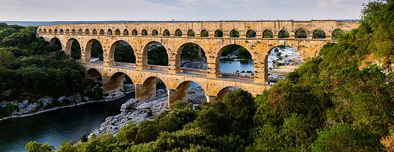
English: Pont du Gard, in Vers-Pont-du-Gard, Gard department, South France. The Pont du Gard is the most famous part of the roman aqueduct which carried water from Uzès to Nîmes until roughly the 9th century when maintenance was abandoned. The monument is 49m high and now 275m long (it was 360m when intact) at its top. It's the highest roman aqueduct, but also one of the best preserved (with the aqueduct of Segovia). The Pont du Gard has been a UNESCO world heritage site since 1985.
Français : Le Pont du Gard, à Vers-Pont-du-Gard, département du Gard, région Languedoc-Roussillon, France. Le Pont du Gard (1er siècle C.E.) est la partie la plus célèbre de l'aqueduc romain qui conduisait l'eau d'Uzès à Nîmes, jusqu'au 9ème siècle où l'on cessa de l'entretenir. Le monument fait 49 mètres de haut et aujourd'hui 275 mètres de long (360 mètres quand il était intact). C'est l'aqueduc roman le plus haut, mais aussi, avec celui de Ségovie, l'un des mieux préservés. Le Pont du Gard est un site du patrimoine mondial de l'humanité de l'UNESCO depuis 1985.
Español: El Pont du Gard (puente del Gard), en Vers-Pont-du-Gard, departamento de Gard, en la región de Languedoc-Rosellón, sur de Francia, es la parte más conocida del acueducto romano que conducía el agua desde Uzès a Nîmes hasta el siglo IX, cuando cesó su actividad. El puente mide 49 metros de alto y 275 metros de largo (360 m cuando se encontraba intacto en la antigüedad). Es el acueducto romano más alto y también, junto al de Segovia, en España, uno de los mejor conservados. El Pont du Gard fue declarado Patrimonio Mundial de la Humanidad por la UNESCO en 1985.
تاريخ
ذريعو Pont du Gard
ليکڪ Benh LIEU SONG (Flickr)
Camera location٤٣° ٥٦′ ٤٤٫٨٤″ N, ٤° ٣٢′ ٠٤٫٥١″ E Kartographer map based on OpenStreetMap.View this and other nearby images on: OpenStreetMapinfo

لائيسنسڪاري

I, the copyright holder of this work, hereby publish it under the following license:
w:en:Creative Commons
انتساب ھڪجھڙي ڀاڱيداري
ھي فائيل ڪريئيٽو ڪامنز انتساب-ھڪجھڙي ڀاڱيداري 3.0 انپورٽڊ اجازتنامي ھيٺ اجازتنامو ڏنل آھي.
توھان آزاد آھيو:
  • ونڊڻ لاءِ – اھو ڪم نقل ڪرڻ، ورڇڻ، ۽ پارمڪارڻ
  • جڳلبندي ڪرڻ – ڪم اختيار ڪرڻ لاءِ
ھيٺين شرطن تي:
  • انتساب – توهان لازماً مناسب انتساب ڏيو، اجازتنامي ڏانھن ڳنڍڻو مھيا ڪريو، ۽ جيڪڏھن ڪي تبديليون ڪيون ويون ھجن تہ انھن جي نشاندھي ڪريو. توهان اهو ڪري سگهو ٿا ڪنھن بہ معقول طريقي سان، پر ڪنھن بہ اھڙي طريقي سان نہ جيڪو ڏسي تہ اجازتنامو ڏيندڙ توهان جي يا توهان جي استعمال جي توثيق ڪري ٿو.
  • ھڪجھڙي ڀاڱيداري – جيڪڏھن توھان ٻيھر ملاوٽ، بدلاءُ، يا مواد تي اڏاوت ڪريو ٿا، توھان کي لازماً پنھنجون ڀاڱيداريون ساڳي يا موافق اجازتنامي جھڙو اصل جو ھيو، ھيٺ ٻيھر-ورھائڻ گهرجن.
Annotations
InfoField
This image is annotated: View the annotations at Commons

عنوان

ھڪ-سٽي وضاحت ڏيو تہ ھي فائيل ڇاکي ٿو ظاھر ڪري
Der Pont du Gard in Südfrankreich

Items portrayed in this file

depicts انگريزي

aqueduct انگريزي

copyright status انگريزي

copyrighted انگريزي

inception انگريزي

11 جُونِ 2014

43°56'44.844"N, 4°32'4.506"E

captured with انگريزي

Canon EOS 7D انگريزي

media type انگريزي

image/jpeg

data size انگريزي

19659964 byte

height انگريزي

4882 عَڪسِل

width انگريزي

12648 عَڪسِل

checksum انگريزي

6a075d632ebd42c6a469303592f5976d92bc2924

فائيل جي سوانح

ڪنھن بہ تاريخ/وقت تي ٽڙڪ ڪري ڏسندا تہ ان وقت اهو فائيل ڪيئن هو.

تاريخ/وقتٽِڪِلِيماپَواپرائيندڙراءِ
هاڻوڪو نسخو17:57, 19 جُونِ 201417:57, 19 جُونِ 2014 جي نظرثاني لاءِ تصويري نشان12,648 × 4,882 (18.75 MB)BenhVerticals.
10:55, 19 جُونِ 201410:55, 19 جُونِ 2014 جي نظرثاني لاءِ تصويري نشان12,648 × 4,771 (18.78 MB)BenhUser created page with UploadWizard

هن فائيل سان هيٺيان صفحا ڳنڍيل آهن.

فائيل جو ٻين وڪيز تي استعمال

ھيٺيون وڪيز بہ ھيءُ فائيل استعمال ڪن ٿيون:

ھن فائيل جو وڌيڪ گلوبل استعمال ڏسو.

اعدادِ اعداد