فائل:English regions 2009.svg

Size of this PNG preview of this SVG file: 494*600 پڪزلس. ٻيا تحلل:198*240 پڪزلس | 395*480 پڪزلس | 633*768 پڪزلس | 843*1,024 پڪزلس | 1,687*2,048 پڪزلس | 1,108*1,345 پڪزلس
اصلوڪو فائيل (ايسويجي فائيل، اٽڪل 1,108 × 1,345 عڪسلون، فائيل سائيز: 365 KB)
تَتُ
| تشريح |
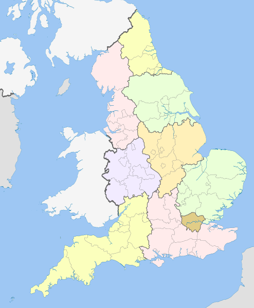
English: Map showing the Regions of England and the constituent metropolitan and non-metropolitan counties, in 2009.
Equirectangular map projection on WGS 84 datum, with N/S stretched 170% Geographic limits:
|
| تاريخ | (UTC) |
| ذريعو |
This file was derived from: English metropolitan and non-metropolitan counties 2010.svg:  |
| ليکڪ |
|
| This is a retouched picture, which means that it has been digitally altered from its original version. Modifications: recoloured with some thicker boundary lines. The original can be viewed here: English metropolitan and non-metropolitan counties 2010.svg:
|
لائيسنسڪاري
I, the copyright holder of this work, hereby publish it under the following licenses:
ھي فائيل ڪريئيٽو ڪامنز انتساب-ھڪجھڙي ڀاڱيداري 3.0 انپورٽڊ اجازتنامي ھيٺ اجازتنامو ڏنل آھي.
انتساب: Nilfanion and Dr Greg
- توھان آزاد آھيو:
- ونڊڻ لاءِ – اھو ڪم نقل ڪرڻ، ورڇڻ، ۽ پارمڪارڻ
- جڳلبندي ڪرڻ – ڪم اختيار ڪرڻ لاءِ
- ھيٺين شرطن تي:
- انتساب – توهان لازماً مناسب انتساب ڏيو، اجازتنامي ڏانھن ڳنڍڻو مھيا ڪريو، ۽ جيڪڏھن ڪي تبديليون ڪيون ويون ھجن تہ انھن جي نشاندھي ڪريو. توهان اهو ڪري سگهو ٿا ڪنھن بہ معقول طريقي سان، پر ڪنھن بہ اھڙي طريقي سان نہ جيڪو ڏسي تہ اجازتنامو ڏيندڙ توهان جي يا توهان جي استعمال جي توثيق ڪري ٿو.
- ھڪجھڙي ڀاڱيداري – جيڪڏھن توھان ٻيھر ملاوٽ، بدلاءُ، يا مواد تي اڏاوت ڪريو ٿا، توھان کي لازماً پنھنجون ڀاڱيداريون ساڳي يا موافق اجازتنامي جھڙو اصل جو ھيو، ھيٺ ٻيھر-ورھائڻ گهرجن.

|
ھن دستاويز کي جي.اين.يو مفت دستاويزسازي اجازتنامي ، مفت سافٽويئر فائونڊيشن پاران ڇاپيل ورزن 1.2 يا ٻي ڪنھن بعد واري ورزن؛ جنھن ۾ نہ انويريئينٽ ڀاڱا، ۽ نہ فونٽ-ڪور متنَ، ۽ نہ بيڪ-ڪور متنَ شامل آھن، جي شرطن ھيٺ نقل ڪرڻ، ورھائن ۽/يا بدلائڻ جي اجازت ڏني وئي آھي. اجازتنامي جو نقل [[c:Commons:GNU Free Documentation License, version 1.2 | جي.اين.يو مفت دستاويزسازي اجازتنامو]] نالي ڀاڱي ۾ ڏنل آھي. |
توھان پنھنجي پسند جو اجازتنامو چونڊي سگهو ٿا.
Original upload log
This image is a derivative work of the following images:
- File:English_metropolitan_and_non-metropolitan_counties_2010.svg licensed with Cc-by-sa-3.0, GFDL
- 2010-11-23T22:01:59Z Nilfanion 1108x1345 (340057 Bytes) England only
- 2010-11-23T22:00:28Z Nilfanion 1108x1345 (376231 Bytes) {{Information |Description=Map showing the [[w:Metropolitan and non-metropolitan counties of England|Metropolitan and non-metropolitan counties of England]], in 2010. Equirectangular map projection on WGS 84 datum, with N/S
Uploaded with derivativeFX
فائيل جي سوانح
ڪنھن بہ تاريخ/وقت تي ٽڙڪ ڪري ڏسندا تہ ان وقت اهو فائيل ڪيئن هو.
| تاريخ/وقت | آڱوٺي ننھن | ماپَ | واپرائيندڙ | راءِ | |
|---|---|---|---|---|---|
| موجود نسخو | 20:04, 21 اپريل 2012 | | 1,108 × 1,345 (365 KB) | Dr Greg | == {{int:filedesc}} == {{Information |Description={{en|Map showing the en:Regions of England and the constituent metropolitan and non-metropolitan counties, in 2009. Equirectangular m... |
ڳنڍڻا
هن فائيل سان هيٺيان صفحا ڳنڍيل آهن.
گلوبل فائيل جو استعمال
ھيٺيون وڪيز بہ ھيءُ فائيل استعمال ڪن ٿيون:
- ban.wikipedia.org تي استعمال
- bg.wikipedia.org تي استعمال
- bs.wikipedia.org تي استعمال
- en.wikipedia.org تي استعمال
- List of forests in the United Kingdom
- Subdivisions of England
- Regional assembly (England)
- Regional development agency
- Lists of schools in England
- User:Ric36/Sandbox
- Talk:Politics of England
- Template:England Labelled Map
- Health in England
- United Kingdom constitutional law
- Local authority leaders' board
- Regions of England
- Constitution of the United Kingdom
- Category:People by region in England
- Category:Cities in England by region
- Category:NUTS 1 statistical regions of England
- Devolution in the United Kingdom
- User talk:Iridescent/Archive 17
- Category:British school stubs
- User:Ric36/sandbox
- User:Bermicourt/Template:Lists of hills of English counties
- List of British regions by life expectancy
- es.wikipedia.org تي استعمال
- fo.wikipedia.org تي استعمال
- fr.wikipedia.org تي استعمال
- hi.wikipedia.org تي استعمال
- id.wikipedia.org تي استعمال
- it.wikipedia.org تي استعمال
- ja.wikipedia.org تي استعمال
- ja.wikibooks.org تي استعمال
- lv.wikipedia.org تي استعمال
- mr.wikipedia.org تي استعمال
- pl.wikipedia.org تي استعمال
- pnb.wikipedia.org تي استعمال
ھن فائيل جو وڌيڪ گلوبل استعمال ڏسو.