فائل:Abu Reyhan Biruni-Earth Circumference.svg

اصلوڪو فائيل (ايسويجي فائيل، اٽڪل 1,000 × 900 عڪسلون، فائيل سائيز: 16 KB)
تَتُ
| تشريح |
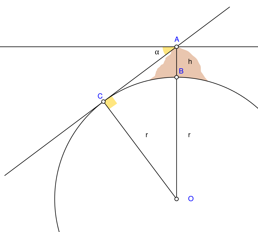
English: Biruni (973 - 1048) developed a new method using trigonometric calculations to compute earth's radius and circumference based on the angle between the horizontal line and true horizon from a mountain top with known height. He calculated the height of the mountain by going to two points at sea level with a known distance apart and then measuring the angle between the plain and the top of the mountain for both points.
Biruni's estimate of 6,339.9 km for the Earth radius had an error of 0.0026 and was 16.8 km less than the current value of 6,356.7 km. The idea came to him when he was on top of a tall mountain near Nandana in Pakistan. He measured the dip angle using an astrolabe and he applied to the law of sines formula. He also made use of algebra in his calculation.
Solution: Français : Biruni (973-1048) développa une nouvelle méthode utilisant la trigonométrie pour calculer le rayon et la ciconférence de la Terre, basée sur l'angle entre la ligne horizontale et l'horizon réel depuis le sommet d'une montagne de hauteur connue. Il calcula la hauteur de la montagne en se rendant en deux points situés au niveau de la mer dont l'écartement était connu, puis en mesurant l'angle entre la ligne horizontale formée par les deux points au niveau de la mer et le sommet de la montagne, et ceci depuis chacun des deux points.
L'estimation de Biruni de 6 339,9 km pour le rayon de la Terre comportait une erreur de 0,26 %, soit une valeur inférieure de 16,8 km par rapport à la valeur actuelle de 6 356,7 km. L'idée lui était venue alors qu'il se trouvait au sommet d'une haute montagne, près de Nandana en Inde. Il mesura l'angle d'incinaison avec un astrolabe et il appliqua la formule des sinus. Il fit également usage de l'algèbre pour ses calculs.
Solution : |
| تاريخ | |
| ذريعو | ڪم پنھنجايو Using Geogebra and Inkscape |
| ليکڪ | Nevit Dilmen |
| SVG genesis | and with GeoGebra. |
لائيسنسڪاري
- توھان آزاد آھيو:
- ونڊڻ لاءِ – اھو ڪم نقل ڪرڻ، ورڇڻ، ۽ پارمڪارڻ
- جڳلبندي ڪرڻ – ڪم اختيار ڪرڻ لاءِ
- ھيٺين شرطن تي:
- انتساب – توهان لازماً مناسب انتساب ڏيو، اجازتنامي ڏانھن ڳنڍڻو مھيا ڪريو، ۽ جيڪڏھن ڪي تبديليون ڪيون ويون ھجن تہ انھن جي نشاندھي ڪريو. توهان اهو ڪري سگهو ٿا ڪنھن بہ معقول طريقي سان، پر ڪنھن بہ اھڙي طريقي سان نہ جيڪو ڏسي تہ اجازتنامو ڏيندڙ توهان جي يا توهان جي استعمال جي توثيق ڪري ٿو.
- ھڪجھڙي ڀاڱيداري – جيڪڏھن توھان ٻيھر ملاوٽ، بدلاءُ، يا مواد تي اڏاوت ڪريو ٿا، توھان کي لازماً پنھنجون ڀاڱيداريون ساڳي يا موافق اجازتنامي جھڙو اصل جو ھيو، ھيٺ ٻيھر-ورھائڻ گهرجن.
فائيل جي سوانح
ڪنھن بہ تاريخ/وقت تي ٽڙڪ ڪري ڏسندا تہ ان وقت اهو فائيل ڪيئن هو.
| تاريخ/وقت | آڱوٺي ننھن | ماپَ | واپرائيندڙ | راءِ | |
|---|---|---|---|---|---|
| موجود نسخو | 05:25, 2 مَئي 2010 | | 1,000 × 900 (16 KB) | Nevit | Crop |
| 05:21, 2 مَئي 2010 |  | 1,390 × 1,220 (16 KB) | Nevit | Yellow removed | |
| 05:19, 2 مَئي 2010 |  | 1,390 × 1,220 (16 KB) | Nevit | Image version | |
| 05:18, 2 مَئي 2010 |  | 640 × 480 (22 KB) | Nevit | {{Information |Description={{en|1=Biruni (973 - 1048) developed a new method using trigonometric calculations to compute earth's circumference based on the angle between the horizontal line and true horizon from a mountain top with known height. He calcu |
ڳنڍڻا
هن فائيل سان هيٺيان صفحا ڳنڍيل آهن.
گلوبل فائيل جو استعمال
ھيٺيون وڪيز بہ ھيءُ فائيل استعمال ڪن ٿيون:
- af.wikipedia.org تي استعمال
- ar.wikipedia.org تي استعمال
- bcl.wikipedia.org تي استعمال
- bn.wikipedia.org تي استعمال
- bs.wikipedia.org تي استعمال
- diq.wikipedia.org تي استعمال
- en.wikipedia.org تي استعمال
- es.wikipedia.org تي استعمال
- fa.wikipedia.org تي استعمال
- fr.wikipedia.org تي استعمال
- he.wikipedia.org تي استعمال
- hr.wikipedia.org تي استعمال
- id.wikipedia.org تي استعمال
- it.wikipedia.org تي استعمال
- ja.wikipedia.org تي استعمال
- ps.wikipedia.org تي استعمال
- pt.wikipedia.org تي استعمال
- pt.wikibooks.org تي استعمال
- ro.wikipedia.org تي استعمال
- ru.wikipedia.org تي استعمال
- sh.wikipedia.org تي استعمال
- sr.wikipedia.org تي استعمال
- ta.wikipedia.org تي استعمال
- tr.wikipedia.org تي استعمال
- tt.wikipedia.org تي استعمال
- uk.wikipedia.org تي استعمال
- uz.wikipedia.org تي استعمال
- www.wikidata.org تي استعمال
ھن فائيل جو وڌيڪ گلوبل استعمال ڏسو.