فائل:Un-kashmir-jammu.png
اصلوڪو فائيل (2,302 × 2,901 عڪسلون، فائيل سائيز: 1.1 MB، MIME ٽائيپ: image/png)
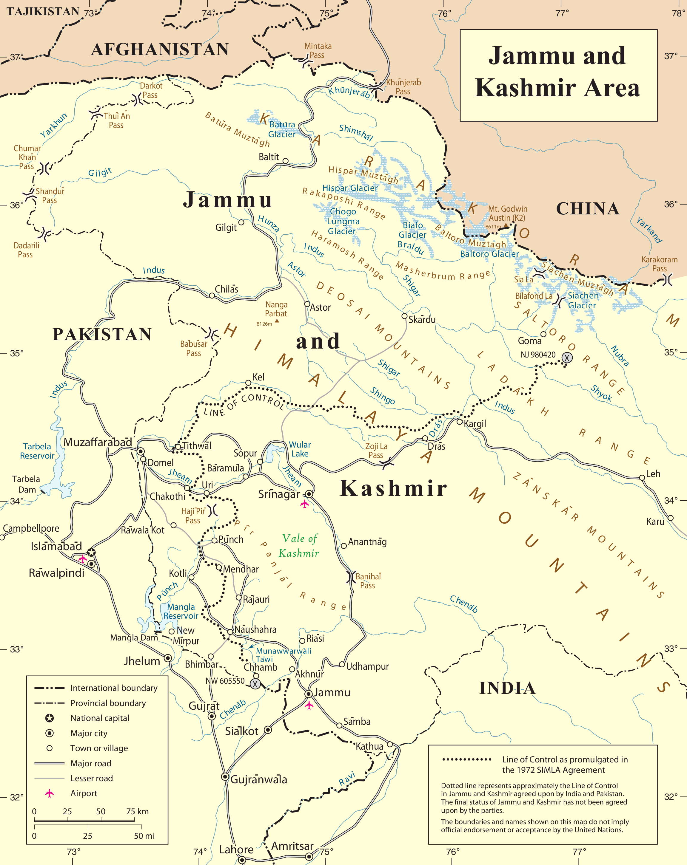
| This image is a map derived from a United Nations map.
Unless stated otherwise, UN maps are to be considered in the public domain. This applies worldwide. UN maps are, in principle, open source material and you can use them in your work or for making your own map. UN requests however that you delete the UN name, logo and reference number upon any modification to the map. Content of your map will be your responsibility. You can state in your publication, if you wish, something like: based on UN map … (map name, map number, revision number and date). See: Geospatial Information Section. And: Geospatial, location data for a better world. |
 |
فائيل جي سوانح
ڪنھن بہ تاريخ/وقت تي ٽڙڪ ڪري ڏسندا تہ ان وقت اهو فائيل ڪيئن هو.
| تاريخ/وقت | آڱوٺي ننھن | ماپَ | واپرائيندڙ | راءِ | |
|---|---|---|---|---|---|
| موجود نسخو | 23:04, 6 جُونِ 2010 | | 2,302 × 2,901 (1.1 MB) | Ras67 | cropped |
| 23:28, 21 آڪٽوبر 2007 |  | 2,348 × 2,947 (1.47 MB) | Jeroen | {{UN map}} Category:Maps of Kashmir |
ڳنڍڻا
هن فائيل سان هيٺيان صفحا ڳنڍيل آهن.
گلوبل فائيل جو استعمال
ھيٺيون وڪيز بہ ھيءُ فائيل استعمال ڪن ٿيون:
- ar.wikipedia.org تي استعمال
- arz.wikipedia.org تي استعمال
- azb.wikipedia.org تي استعمال
- be-tarask.wikipedia.org تي استعمال
- be.wikipedia.org تي استعمال
- bn.wikipedia.org تي استعمال
- ca.wikipedia.org تي استعمال
- ceb.wikipedia.org تي استعمال
- en.wikipedia.org تي استعمال
- Hunza (princely state)
- Line of Control
- Indo-Pakistani war of 1947–1948
- Siachen Glacier
- Yarkand River
- Kashmir conflict
- Saltoro Mountains
- Ghent Kangri
- Nowshera, Jammu and Kashmir
- Siachen conflict
- Bilafond La
- Sia La
- Gyong La
- Siachen Base Camp (India)
- Actual Ground Position Line
- Wikipedia:Graphics Lab/Map workshop/Archive/Aug 2011
- Chumik Glacier
- Saltoro Valley
- User:Falcaorib
- User:Johnleeds1/Kashmir conflict
- es.wikipedia.org تي استعمال
- fa.wikipedia.org تي استعمال
- fr.wikipedia.org تي استعمال
- he.wikipedia.org تي استعمال
ھن فائيل جو وڌيڪ گلوبل استعمال ڏسو.