فائل:Partition of India-en.svg

Size of this PNG preview of this SVG file: 514*600 پڪزلس. ٻيا تحلل:206*240 پڪزلس | 411*480 پڪزلس | 658*768 پڪزلس | 877*1,024 پڪزلس | 1,755*2,048 پڪزلس | 718*838 پڪزلس
اصلوڪو فائيل (ايسويجي فائيل، اٽڪل 718 × 838 عڪسلون، فائيل سائيز: 44 KB)

| تشريح |
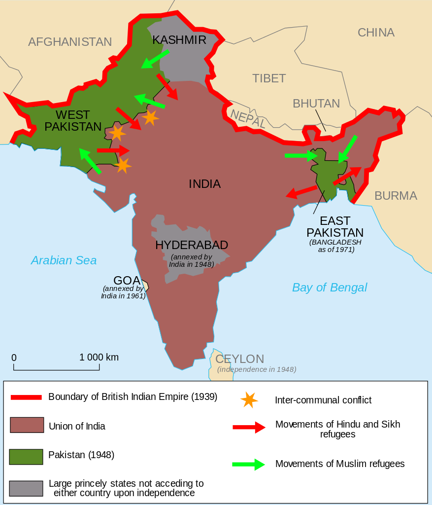
English: The partition of India (1947)
Français : La partition des Indes (1947)
Español: La partición de la India (1947)
اردو: تقسیم ہند کا نقشہ (1947ء) |
| تاريخ | (UTC) |
| ذريعو | |
| ليکڪ |
|
| Other versions |
[]
|


.svg)


I, the copyright holder of this work, hereby publish it under the following licenses:
This file is licensed under the Creative Commons Attribution-Share Alike 2.5 Generic, 2.0 Generic and 1.0 Generic license.
- توھان آزاد آھيو:
- ونڊڻ لاءِ – اھو ڪم نقل ڪرڻ، ورڇڻ، ۽ پارمڪارڻ
- جڳلبندي ڪرڻ – ڪم اختيار ڪرڻ لاءِ
- ھيٺين شرطن تي:
- انتساب – توهان لازماً مناسب انتساب ڏيو، اجازتنامي ڏانھن ڳنڍڻو مھيا ڪريو، ۽ جيڪڏھن ڪي تبديليون ڪيون ويون ھجن تہ انھن جي نشاندھي ڪريو. توهان اهو ڪري سگهو ٿا ڪنھن بہ معقول طريقي سان، پر ڪنھن بہ اھڙي طريقي سان نہ جيڪو ڏسي تہ اجازتنامو ڏيندڙ توهان جي يا توهان جي استعمال جي توثيق ڪري ٿو.
- ھڪجھڙي ڀاڱيداري – جيڪڏھن توھان ٻيھر ملاوٽ، بدلاءُ، يا مواد تي اڏاوت ڪريو ٿا، توھان کي لازماً پنھنجون ڀاڱيداريون ساڳي يا موافق اجازتنامي جھڙو اصل جو ھيو، ھيٺ ٻيھر-ورھائڻ گهرجن.
| ھي فائيل ڪريئيٽو ڪامنز انتساب-ھڪجھڙي ڀاڱيداري 3.0 انپورٽڊ اجازتنامي ھيٺ اجازتنامو ڏنل آھي. | ||
| ||
| This licensing tag was added to this file as part of the GFDL licensing update. |

|
ھن دستاويز کي جي.اين.يو مفت دستاويزسازي اجازتنامي ، مفت سافٽويئر فائونڊيشن پاران ڇاپيل ورزن 1.2 يا ٻي ڪنھن بعد واري ورزن؛ جنھن ۾ نہ انويريئينٽ ڀاڱا، ۽ نہ فونٽ-ڪور متنَ، ۽ نہ بيڪ-ڪور متنَ شامل آھن، جي شرطن ھيٺ نقل ڪرڻ، ورھائن ۽/يا بدلائڻ جي اجازت ڏني وئي آھي. اجازتنامي جو نقل [[c:Commons:GNU Free Documentation License, version 1.2 | جي.اين.يو مفت دستاويزسازي اجازتنامو]] نالي ڀاڱي ۾ ڏنل آھي. |
توھان پنھنجي پسند جو اجازتنامو چونڊي سگهو ٿا.

|
This SVG file contains embedded text that can be translated into your language, using any capable SVG editor, text editor or the SVG Translate tool. For more information see: About translating SVG files. |
Original upload log
This image is a derivative work of the following images:
- File:Partage_de_l'Inde.svg licensed with Cc-by-sa-2.5,2.0,1.0, Cc-by-sa-3.0-migrated, GFDL
- 2010-11-16T18:17:32Z Historicair 721x841 (63365 Bytes) orth
- 2006-11-19T17:15:11Z Historicair 721x841 (63821 Bytes) {{Information |Description={{fr|1=La partition des Indes (1947) }}{{en|1=The partition of India (1947)}} |Source=Own work |Date=19/11/2006 |Author=~~~~ |Permission={{self2|GFDL|cc-by-sa-2.5,2.0,1.0}} |other_versions= }} {{Atelier
Uploaded with derivativeFX
فائيل جي سوانح
ڪنھن بہ تاريخ/وقت تي ٽڙڪ ڪري ڏسندا تہ ان وقت اهو فائيل ڪيئن هو.
| تاريخ/وقت | آڱوٺي ننھن | ماپَ | واپرائيندڙ | راءِ | |
|---|---|---|---|---|---|
| موجود نسخو | 19:41, 31 جنوري 2014 | | 718 × 838 (44 KB) | Themightyquill | Changes to legend. See talk |
| 20:46, 27 مارچ 2013 |  | 718 × 838 (44 KB) | Themightyquill | remove extra star | |
| 20:40, 27 مارچ 2013 |  | 718 × 838 (45 KB) | Themightyquill | As per talk: Removed China border disputes, removed "areas of riot" completely, changed "British India" label to "British Raj" and added Goa. Further comments & suggestions welcome. | |
| 23:33, 21 نومبر 2011 |  | 718 × 838 (52 KB) | Kintetsubuffalo | Reverted to version as of 23:11, 21 January 2011-anachronism, in that time period, there was | |
| 19:57, 21 نومبر 2011 |  | 718 × 838 (52 KB) | Quigley | No international border between Tibet and the rest of China | |
| 23:11, 21 جنوري 2011 |  | 718 × 838 (52 KB) | Themightyquill | remove remaining border | |
| 23:09, 21 جنوري 2011 |  | 719 × 838 (52 KB) | Themightyquill | removed border | |
| 19:28, 5 ڊسمبر 2010 |  | 721 × 841 (60 KB) | Themightyquill | adjusted borders of bangladesh | |
| 19:27, 5 ڊسمبر 2010 |  | 721 × 841 (60 KB) | Themightyquill | Adjusted borders of Bangladesh | |
| 18:16, 5 ڊسمبر 2010 |  | 721 × 841 (60 KB) | Themightyquill | {{Information |Description={{en}}The partition of India (1947) {{fr}}La partition des Indes (1947) |Source=*File:Partage_de_l'Inde.svg |Date=2010-12-05 18:14 (UTC) |Author=*File:Partage_de_l'Inde.svg: historicair 17:15, 1 |
ڳنڍڻا
ڪي بہ صفحا ناھن جيڪي ھن فائيل کي استعمال ڪندا ھجن.
گلوبل فائيل جو استعمال
ھيٺيون وڪيز بہ ھيءُ فائيل استعمال ڪن ٿيون:
- es.wikipedia.org تي استعمال
- id.wikipedia.org تي استعمال
- ru.wikipedia.org تي استعمال