فائل:Outline Map of Crimea (disputed status).svg

Size of this PNG preview of this SVG file: 800*542 پڪزلس. ٻيا تحلل:320*217 پڪزلس | 640*434 پڪزلس | 1,024*694 پڪزلس | 1,280*868 پڪزلس | 2,560*1,736 پڪزلس | 1,000*678 پڪزلس
اصلوڪو فائيل (ايسويجي فائيل، اٽڪل 1,000 × 678 عڪسلون، فائيل سائيز: 48 KB)
.svg)

|
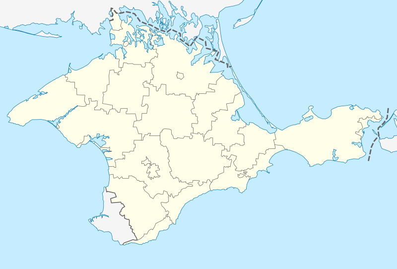
The boundaries on this map show the de facto situation. This is just one of several different views on the subject (see COM:NPOV). |
تَتُ
| تشريح |
English: Location map of the disputed Autonomous Republic of Crimea (Ukraine)/Republic of Crimea/Russia
Conformal projection, standard parallels — 45°15's.W. Template parameters (coordinates of the edges):
|
| تاريخ | |
| ذريعو |
|
| ليکڪ | NordNordWest |
| Other versions |
Derivative works of this file: Relief map of Crimea.jpg |
لائيسنسڪاري
| I, the copyright holder of this work, release this work into the public domain. This applies worldwide. In some countries this may not be legally possible; if so: I grant anyone the right to use this work for any purpose, without any conditions, unless such conditions are required by law. |
فائيل جي سوانح
ڪنھن بہ تاريخ/وقت تي ٽڙڪ ڪري ڏسندا تہ ان وقت اهو فائيل ڪيئن هو.
| تاريخ/وقت | آڱوٺي ننھن | ماپَ | واپرائيندڙ | راءِ | |
|---|---|---|---|---|---|
| موجود نسخو | 17:01, 22 مارچ 2014 | | 1,000 × 678 (48 KB) | NordNordWest | c |
| 16:55, 22 مارچ 2014 |  | 1,000 × 678 (55 KB) | NordNordWest | {{De facto boundaries}} == {{int:filedesc}} == {{Information |Description ={{de|1=Positionskarte der umstrittenen Autonomen Republik Krim (Ukraine)/Republik Krim (Russland)}} {{en|1=Location map of t... |
ڳنڍڻا
هن فائيل سان هيٺيان صفحا ڳنڍيل آهن.
گلوبل فائيل جو استعمال
ھيٺيون وڪيز بہ ھيءُ فائيل استعمال ڪن ٿيون:
- als.wikipedia.org تي استعمال
- azb.wikipedia.org تي استعمال
- اوپولزنو
- اوخوتنیچ
- زوزرن، روسیه
- اوریندا، روسیه
- لاواندا، روسیه
- لنین، روسیه
- اوکتیابرزک
- ساکی، روسیه
- لیسن، روسیه
- ساناتورن
- لینیین، روسیه
- لیوادییا، روسیه
- اولیوا، روسیه
- بویوک کارئیلز
- ماسسندرا
- پارتنیت، روسیه
- پارتیزانزک
- پارکوو، روسیه
- پروالن، روسیه
- پروالیوکا
- ایستاری کریم
- پروومایسک ، روسیه
- پریبرژن، روسیه
- سوکولین، روسیه
- مورزک، روسیه
- سونیاچنا دولینا
- آزووسک، روسیه
- آلوپکا، روسیه
- باهاتیوکا، روسیه
- برهوو، روسیه
- پونیزیوکا
- چورنومورزک
- خولودیوکا، روسیه
- داچن، روسیه
- دانیلیوکا
- روزدولن، روسیه
- سوویتایسکایی
- سوویتسک، روسیه
- سیمئیز، روسیه
- شچولکین، روسیه
- فوروز، قیریم
- قاسپرا
- قورزوف
- کاتسیولی
- کاچا، قیریم
- کراسنوکامیانکا
- کراسنوهواردییسک
- کورپاتی، روسیه
- کورئیز، روسیه
ھن فائيل جو وڌيڪ گلوبل استعمال ڏسو.
.svg)
.svg)