فائل:NorthAmericaDivides.gif
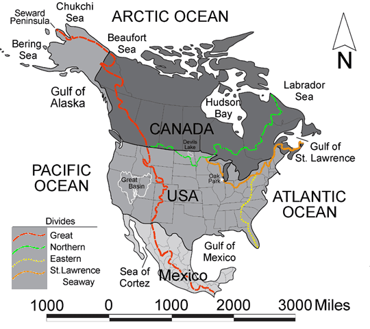
NorthAmericaDivides.gif (540 × 481 عڪسلون، فائيل سائيز: 56 KB، MIME ٽائيپ: image/gif)
فائيل جي سوانح
ڪنھن بہ تاريخ/وقت تي ٽڙڪ ڪري ڏسندا تہ ان وقت اهو فائيل ڪيئن هو.
| تاريخ/وقت | ٽِڪِلِي | ماپَ | واپرائيندڙ | راءِ | |
|---|---|---|---|---|---|
| هاڻوڪو نسخو | 22:27, 20 فيبروري 2005 |  | 540 × 481 (56 KB) | Don Braffitt | North America Continental Divides |
ڳنڍڻا
ڪي بہ صفحا ناھن جيڪي ھن فائيل کي استعمال ڪندا ھجن.
فائيل جو ٻين وڪيز تي استعمال
ھيٺيون وڪيز بہ ھيءُ فائيل استعمال ڪن ٿيون:
- bg.wikipedia.org تي استعمال
- ca.wikipedia.org تي استعمال
- de.wikipedia.org تي استعمال
- de.wiktionary.org تي استعمال
- en.wikibooks.org تي استعمال
- en.wiktionary.org تي استعمال
- es.wikipedia.org تي استعمال
- fi.wikipedia.org تي استعمال
- fr.wikipedia.org تي استعمال
- he.wikipedia.org تي استعمال
- it.wikipedia.org تي استعمال
- nl.wikipedia.org تي استعمال
- pl.wikipedia.org تي استعمال
- pt.wikipedia.org تي استعمال
- sr.wikinews.org تي استعمال
- САД и Канада захваћене таласом великих врућина
- Шаблон:Северна Америка
- Препешачио Нијагарине водопаде ходајући по жици
- У снежној олуји у Северној Америци 15 мртвих
- Нови талас рекордне хладноће у Северној Америци
- Снег, лед и велике хладноће у САД
- У САД и даље велике хладноће и невреме
- У САД најмање 21 преминулих због велике хладноће
- Попушта ледени талас у САД и Канади
- Поново невреме у САД
- Нова снежна олуја погодила исток САД
- Нова снежна олуја у Канади и САД
- Порекло данашњих Индијанаца од пре 12.600 година
- Залеђена Велика језера у Мичигену
- Вирус Зика се рапидно шири
- uk.wikipedia.org تي استعمال


