فائل:MH -map A.png

هن پيش-نگاھ جي ماپ: 740*600 پڪزلس. ٻيا تحلل:296*240 پڪزلس | 592*480 پڪزلس | 950*770 پڪزلس
اصلوڪو فائيل (950 × 770 عڪسلون، فائيل سائيز: 20 KB، MIME ٽائيپ: image/png)

|
This locator map image could be re-created using vector graphics as an SVG file. This has several advantages; see Commons:Media for cleanup for more information. If an SVG form of this image is available, please upload it and afterwards replace this template with
{{vector version available|new image name}}.
It is recommended to name the SVG file “MH -map A.svg”—then the template Vector version available (or Vva) does not need the new image name parameter. |
تَتُ
| تشريح |
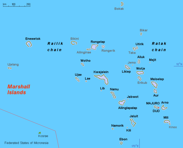
English: Map (rough) Marshall islands, own work composed from various mapreferences |
| تاريخ | |
| ذريعو | ڪم پنھنجايو |
| ليکڪ | Hobe / Holger Behr |
| Other versions |
Derivative works of this file: Operation K Map.jpg
|
لائيسنسڪاري
| I, the copyright holder of this work, release this work into the public domain. This applies worldwide. In some countries this may not be legally possible; if so: I grant anyone the right to use this work for any purpose, without any conditions, unless such conditions are required by law. |
فائيل جي سوانح
ڪنھن بہ تاريخ/وقت تي ٽڙڪ ڪري ڏسندا تہ ان وقت اهو فائيل ڪيئن هو.
| تاريخ/وقت | آڱوٺي ننھن | ماپَ | واپرائيندڙ | راءِ | |
|---|---|---|---|---|---|
| موجود نسخو | 13:44, 11 نومبر 2010 | | 950 × 770 (20 KB) | Hobe | minor design change, restored origional uploader |
| 04:03, 17 سيپٽمبر 2010 |  | 950 × 775 (31 KB) | Lasunncty | uninhabited islands/atolls in grey | |
| 17:59, 19 مارچ 2008 |  | 950 × 775 (20 KB) | Hobe | map (rough) Marshall islands, larger letters Source: self-made, composed from various mapreferences Date 2008-03-13 Author Hobe Category:Maps of the Marshall Islands | |
| 18:27, 16 مارچ 2008 |  | 950 × 650 (17 KB) | Hobe | {{Information |Description=map (rough) Marshall islands |Source=self-made, composed from various mapreferences |Date=2008-03-03 |Author= Hobe |Permission= |other_versions= Category:Maps of the Marshall Islands }} Source |
ڳنڍڻا
هن فائيل سان هيٺيان صفحا ڳنڍيل آهن.
گلوبل فائيل جو استعمال
ھيٺيون وڪيز بہ ھيءُ فائيل استعمال ڪن ٿيون:
- af.wikipedia.org تي استعمال
- ami.wikipedia.org تي استعمال
- ar.wikipedia.org تي استعمال
- ast.wikipedia.org تي استعمال
- ba.wikipedia.org تي استعمال
- br.wikipedia.org تي استعمال
- ca.wikipedia.org تي استعمال
- da.wikipedia.org تي استعمال
- el.wikipedia.org تي استعمال
- en.wikipedia.org تي استعمال
- en.wiktionary.org تي استعمال
- es.wikipedia.org تي استعمال
- eu.wikipedia.org تي استعمال
- fa.wikipedia.org تي استعمال
- fi.wikipedia.org تي استعمال
- fr.wikipedia.org تي استعمال
- gl.wikipedia.org تي استعمال
ھن فائيل جو وڌيڪ گلوبل استعمال ڏسو.