فائل:LA County Incorporated Areas Los Angeles highlighted.svg

Size of this PNG preview of this SVG file: 730*599 پڪزلس. ٻيا تحلل:292*240 پڪزلس | 585*480 پڪزلس | 935*768 پڪزلس | 1,247*1,024 پڪزلس | 2,494*2,048 پڪزلس | 950*780 پڪزلس
اصلوڪو فائيل (ايسويجي فائيل، اٽڪل 950 × 780 عڪسلون، فائيل سائيز: 261 KB)
تَتُ
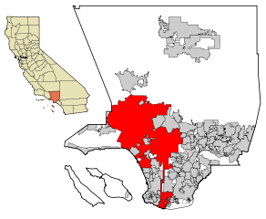
| تشريح | This map shows the incorporated areas in Los Angeles County, California. Los Angeles is highlighted in red. I created it in Inkscape using data from the Los Angeles County Website (Los Angeles County Incorporated Area and District Map (PDF). |
| تاريخ | |
| ذريعو | My own work, based on public domain information. Though I strove to be as accurate in the detail as possible, the information shown is not guaranteed to be completely accurate. |
| ليکڪ | Ixnayonthetimmay |
| اجازت (ھن فائيل کي وَراستعمال ڪندي) |
Public Domain |
| Other versions | See Category:Maps of Los Angeles County, California for other versions of this image. |
لائيسنسڪاري
| I, the copyright holder of this work, release this work into the public domain. This applies worldwide. In some countries this may not be legally possible; if so: I grant anyone the right to use this work for any purpose, without any conditions, unless such conditions are required by law. |
فائيل جي سوانح
ڪنھن بہ تاريخ/وقت تي ٽڙڪ ڪري ڏسندا تہ ان وقت اهو فائيل ڪيئن هو.
| تاريخ/وقت | آڱوٺي ننھن | ماپَ | واپرائيندڙ | راءِ | |
|---|---|---|---|---|---|
| موجود نسخو | 07:19, 26 جُونِ 2007 | | 950 × 780 (261 KB) | Ixnayonthetimmay | == Summary == {{Information |Description=This map shows the incorporated areas in Los Angeles County, California. Los Angeles is highlighted in |
ڳنڍڻا
هن فائيل سان هيٺيان صفحا ڳنڍيل آهن.
گلوبل فائيل جو استعمال
ھيٺيون وڪيز بہ ھيءُ فائيل استعمال ڪن ٿيون:
- af.wikipedia.org تي استعمال
- als.wikipedia.org تي استعمال
- ang.wikipedia.org تي استعمال
- ar.wikipedia.org تي استعمال
- arz.wikipedia.org تي استعمال
- ast.wikipedia.org تي استعمال
- azb.wikipedia.org تي استعمال
- bg.wikipedia.org تي استعمال
- bh.wikipedia.org تي استعمال
- bn.wikipedia.org تي استعمال
- ca.wikipedia.org تي استعمال
- chy.wikipedia.org تي استعمال
- de.wikipedia.org تي استعمال
- diq.wikipedia.org تي استعمال
- dty.wikipedia.org تي استعمال
- el.wikipedia.org تي استعمال
- en.wikipedia.org تي استعمال
- Los Angeles
- Los Angeles Police Department
- Harbor Gateway, Los Angeles
- Municipal annexation in the United States
- Category:Neighborhoods in Los Angeles
- National Register of Historic Places listings in Los Angeles
- Killing of Ezell Ford
- Wikipedia talk:WikiProject China/Archive 26
- Talk:New York (state)/Archive 7
- User:Hparham865
- User:Nate.beisheim/sandbox10
- en.wikinews.org تي استعمال
- es.wikipedia.org تي استعمال
- eu.wikipedia.org تي استعمال
- ext.wikipedia.org تي استعمال
- fa.wikipedia.org تي استعمال
- fi.wikipedia.org تي استعمال
- fo.wikipedia.org تي استعمال
- fr.wikipedia.org تي استعمال
- Los Angeles
- Projet:Charte graphique/Domaine géographique
- Los Angeles Police Department
- Modèle:Infobox Ville des États-Unis
- Modèle:Infobox Ville des États-Unis/Documentation
- Gangster Squad (LAPD)
- Community Resources Against Street Hoodlums
- Division métropolitaine du Los Angeles Police Department
- Modèle:Infobox Ville des États-Unis/Bac à sable
- fr.wikinews.org تي استعمال
- fy.wikipedia.org تي استعمال
ھن فائيل جو وڌيڪ گلوبل استعمال ڏسو.