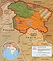
فائل:Kashmir map.jpg

هن پيش-نگاھ جي ماپ: 521*599 پڪزلس. ٻيا تحلل:209*240 پڪزلس | 417*480 پڪزلس | 974*1,120 پڪزلس
اصلوڪو فائيل (974 × 1,120 عڪسلون، فائيل سائيز: 807 KB، MIME ٽائيپ: image/jpeg)
فائيل جي سوانح
ڪنھن بہ تاريخ/وقت تي ٽڙڪ ڪري ڏسندا تہ ان وقت اهو فائيل ڪيئن هو.
| تاريخ/وقت | آڱوٺي ننھن | ماپَ | واپرائيندڙ | راءِ | |
|---|---|---|---|---|---|
| موجود نسخو | 08:34, 6 مارچ 2016 |  | 974 × 1,120 (807 KB) | Denniss | Reverted to version as of 23:18, 6 June 2010 (UTC) |
| 23:18, 6 جُونِ 2010 |  | 974 × 1,120 (807 KB) | Ras67 | slightly rotated and cropped | |
| 19:55, 10 سيپٽمبر 2007 |  | 1,029 × 1,209 (310 KB) | Timeshifter | Larger version of the same CIA map. {{PD-USGov-CIA-WF}} | |
| 08:08, 13 جُونِ 2005 |  | 470 × 565 (72 KB) | Emuzesto | From en:. Original text: The Disputed Territory : Shown in green is Kashmiri region under Pakistani control. The dark-brown region represents Indian-controlled Jammu and Kashmir while the Aksai Chin is under Chinese occupati |
ڳنڍڻا
هن فائيل سان هيٺيان صفحا ڳنڍيل آهن.
گلوبل فائيل جو استعمال
ھيٺيون وڪيز بہ ھيءُ فائيل استعمال ڪن ٿيون:
- ar.wikipedia.org تي استعمال
- az.wikipedia.org تي استعمال
- bh.wikipedia.org تي استعمال
- bn.wikipedia.org تي استعمال
- bpy.wikipedia.org تي استعمال
- ca.wikipedia.org تي استعمال
- cs.wikipedia.org تي استعمال
- de.wikipedia.org تي استعمال
- el.wikipedia.org تي استعمال
- en.wikipedia.org تي استعمال
- Pakistan
- Talk:List of ongoing armed conflicts
- User talk:Vkvora2001
- Operation Meghdoot
- Saltoro Mountains
- Ghent Kangri
- Talk:India/Archive 18
- Bilafond La
- Sia La
- Portal:Maps/Maps/Political
- User:Mattisse//Maps
- Conrad O'Brien-ffrench
- Portal:Maps/Maps/Political/13
- Gyong La
- Siachen Base Camp (India)
- Actual Ground Position Line
- Talk:Azad Kashmir/Archives/2011–2012
- Chumik Glacier
- User:Sofishahidanzwalla Anantnag
- User talk:Sofishahidanzwalla Anantnag
- Saltoro Valley
- User:Falcaorib
- 1992 India–Pakistan floods
- fa.wikipedia.org تي استعمال
- fr.wikipedia.org تي استعمال
- gl.wikipedia.org تي استعمال
- hi.wikipedia.org تي استعمال
ھن فائيل جو وڌيڪ گلوبل استعمال ڏسو.
