فائل:Cn-map.png
اڃان سنھو تحلل ميسر ناھي.
Cn-map.png (330 × 355 عڪسلون، فائيل سائيز: 6 KB، MIME ٽائيپ: image/png)

|
This locator map image could be re-created using vector graphics as an SVG file. This has several advantages; see Commons:Media for cleanup for more information. If an SVG form of this image is available, please upload it and afterwards replace this template with
{{vector version available|new image name}}.
It is recommended to name the SVG file “Cn-map.svg”—then the template Vector version available (or Vva) does not need the new image name parameter. |
تَتُ
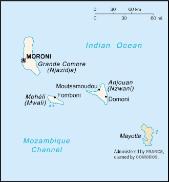
CIA map of the Comoros
لائيسنسڪاري
This image is in the public domain because it contains materials that originally came from the United States Central Intelligence Agency's World Factbook.
|
 |
derivative works
Derivative works of this file:
فائيل جي سوانح
ڪنھن بہ تاريخ/وقت تي ٽڙڪ ڪري ڏسندا تہ ان وقت اهو فائيل ڪيئن هو.
| تاريخ/وقت | آڱوٺي ننھن | ماپَ | واپرائيندڙ | راءِ | |
|---|---|---|---|---|---|
| موجود نسخو | 20:13, 28 فيبروري 2005 | | 330 × 355 (6 KB) | Alfio | CIA map of Comoros |
ڳنڍڻا
هن فائيل سان هيٺيان صفحا ڳنڍيل آهن.
گلوبل فائيل جو استعمال
ھيٺيون وڪيز بہ ھيءُ فائيل استعمال ڪن ٿيون:
- ab.wikipedia.org تي استعمال
- als.wikipedia.org تي استعمال
- ar.wikipedia.org تي استعمال
- ast.wikipedia.org تي استعمال
- be-tarask.wikipedia.org تي استعمال
- be.wikipedia.org تي استعمال
- bjn.wikipedia.org تي استعمال
- bn.wikipedia.org تي استعمال
- bs.wikipedia.org تي استعمال
- ceb.wikipedia.org تي استعمال
- cy.wikipedia.org تي استعمال
- da.wikipedia.org تي استعمال
- de.wikinews.org تي استعمال
- el.wikipedia.org تي استعمال
- en.wikipedia.org تي استعمال
- es.wikipedia.org تي استعمال
- eu.wikipedia.org تي استعمال
- fa.wikipedia.org تي استعمال
- fi.wikipedia.org تي استعمال
- frr.wikipedia.org تي استعمال
- fr.wikipedia.org تي استعمال
- fr.wikinews.org تي استعمال
- gd.wikipedia.org تي استعمال
- gl.wikipedia.org تي استعمال
- he.wikipedia.org تي استعمال
- hi.wikipedia.org تي استعمال
- hi.wiktionary.org تي استعمال
- hu.wikipedia.org تي استعمال
- hu.wiktionary.org تي استعمال
- id.wikipedia.org تي استعمال
ھن فائيل جو وڌيڪ گلوبل استعمال ڏسو.