فائل:ClimateMajuroMarshallIslands.PNG
اڃان سنھو تحلل ميسر ناھي.
ClimateMajuroMarshallIslands.PNG (450 × 450 عڪسلون، فائيل سائيز: 3 KB، MIME ٽائيپ: image/png)

|
This graph image could be re-created using vector graphics as an SVG file. This has several advantages; see Commons:Media for cleanup for more information. If an SVG form of this image is available, please upload it and afterwards replace this template with
{{vector version available|new image name}}.
It is recommended to name the SVG file “ClimateMajuroMarshallIslands.svg”—then the template Vector version available (or Vva) does not need the new image name parameter. |
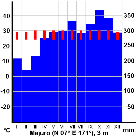
Climate diagram of Majuro, Marshall Islands
max. and min. temperature and total precipitations per month
drawn by Miaow Miaow, April 2005
| I, the copyright holder of this work, release this work into the public domain. This applies worldwide. In some countries this may not be legally possible; if so: I grant anyone the right to use this work for any purpose, without any conditions, unless such conditions are required by law. |
فائيل جي سوانح
ڪنھن بہ تاريخ/وقت تي ٽڙڪ ڪري ڏسندا تہ ان وقت اهو فائيل ڪيئن هو.
| تاريخ/وقت | آڱوٺي ننھن | ماپَ | واپرائيندڙ | راءِ | |
|---|---|---|---|---|---|
| موجود نسخو | 20:14, 1 اپريل 2005 | | 450 × 450 (3 KB) | Miaow Miaow | Climate diagram of Majuro, Marshall Islands |
ڳنڍڻا
هن فائيل سان هيٺيان صفحا ڳنڍيل آهن.
گلوبل فائيل جو استعمال
ھيٺيون وڪيز بہ ھيءُ فائيل استعمال ڪن ٿيون:
- ar.wikipedia.org تي استعمال
- bg.wikipedia.org تي استعمال
- cs.wikipedia.org تي استعمال
- de.wikipedia.org تي استعمال
- de.wikivoyage.org تي استعمال
- el.wikipedia.org تي استعمال
- en.wikipedia.org تي استعمال
- es.wikipedia.org تي استعمال
- et.wikipedia.org تي استعمال
- hy.wikipedia.org تي استعمال
- ka.wikipedia.org تي استعمال
- la.wikipedia.org تي استعمال
- ml.wikipedia.org تي استعمال
- ru.wikipedia.org تي استعمال
- uk.wikipedia.org تي استعمال