فائل:Chagatai Khanate (1490).png

هن پيش-نگاھ جي ماپ: 800*451 پڪزلس. ٻيا تحلل:320*180 پڪزلس | 640*360 پڪزلس | 1,202*677 پڪزلس
اصلوڪو فائيل (1,202 × 677 عڪسلون، فائيل سائيز: 792 KB، MIME ٽائيپ: image/png)
.png)
تَتُ
| تشريح |
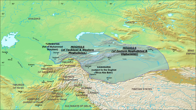
English: A map of the Moghul Chagatai Khanate in 1490 CE. Note: This map is compressed in vertical direction. Please, expand it about 1.3 times to see it undistorted.
ReferencesInformation for the borders of the Moghul khanate came mostly from these two sources:
|
| تاريخ | 22 جُولاءِ 2008 (original upload date) |
| ذريعو | Transferred from en.wikipedia to Commons by Betta27. |
| ليکڪ | Ro4444 at انگريزي وڪيپيڊيا |
لائيسنسڪاري
Ro4444 at the English Wikipedia, the copyright holder of this work, hereby publishes it under the following license:

|
ھن دستاويز کي جي.اين.يو مفت دستاويزسازي اجازتنامي ، مفت سافٽويئر فائونڊيشن پاران ڇاپيل ورزن 1.2 يا ٻي ڪنھن بعد واري ورزن؛ جنھن ۾ نہ انويريئينٽ ڀاڱا، ۽ نہ فونٽ-ڪور متنَ، ۽ نہ بيڪ-ڪور متنَ شامل آھن، جي شرطن ھيٺ نقل ڪرڻ، ورھائن ۽/يا بدلائڻ جي اجازت ڏني وئي آھي. اجازتنامي جو نقل [[c:Commons:GNU Free Documentation License, version 1.2 | جي.اين.يو مفت دستاويزسازي اجازتنامو]] نالي ڀاڱي ۾ ڏنل آھي. |
| ھي فائيل ڪريئيٽو ڪامنز انتساب-ھڪجھڙي ڀاڱيداري 3.0 انپورٽڊ اجازتنامي ھيٺ اجازتنامو ڏنل آھي. | ||
| انتساب: Ro4444 at the English Wikipedia | ||
| ||
| This licensing tag was added to this file as part of the GFDL licensing update. |
Original upload log
The original description page was here. All following user names refer to en.wikipedia.
- 2008-07-22 06:20 Ro4444 1202×677× (811049 bytes) {{Information |Description={{en|1=A map of the Moghul (Chagatai) Khanate in 1490}} |Source=Own work by uploader |Author=ro4444 |Date=22 July 2008 |Permission= |other_versions= }} {{ImageUpload|full}} ==References== Information for the borders of the Mog
]]
فائيل جي سوانح
ڪنھن بہ تاريخ/وقت تي ٽڙڪ ڪري ڏسندا تہ ان وقت اهو فائيل ڪيئن هو.
| تاريخ/وقت | آڱوٺي ننھن | ماپَ | واپرائيندڙ | راءِ | |
|---|---|---|---|---|---|
| موجود نسخو | 07:16, 30 آڪٽوبر 2010 | | 1,202 × 677 (792 KB) | Betta27 | {{Information |Description={{en|''no original description''}} |Source=Transferred from [http://en.wikipedia.org en.wikipedia]; transfer was stated to be made by User:Betta27. |Date={{Date|2008|07|22}} (original upload date) |Author=. Original uploader |
ڳنڍڻا
هن فائيل سان هيٺيان صفحا ڳنڍيل آهن.
گلوبل فائيل جو استعمال
ھيٺيون وڪيز بہ ھيءُ فائيل استعمال ڪن ٿيون:
- azb.wikipedia.org تي استعمال
- de.wikipedia.org تي استعمال
- en.wikipedia.org تي استعمال
- es.wikipedia.org تي استعمال
- fa.wikipedia.org تي استعمال
- fr.wikipedia.org تي استعمال
- it.wikipedia.org تي استعمال
- ja.wikipedia.org تي استعمال
- ko.wikipedia.org تي استعمال
- lt.wikipedia.org تي استعمال
- mni.wikipedia.org تي استعمال
- mn.wikipedia.org تي استعمال
- no.wikipedia.org تي استعمال
- ru.wikipedia.org تي استعمال
- sl.wikipedia.org تي استعمال
- ta.wikipedia.org تي استعمال
- tr.wikipedia.org تي استعمال
- uz.wikipedia.org تي استعمال
- vi.wikipedia.org تي استعمال
- zh.wikipedia.org تي استعمال
.png)