فائل:BritishEmpire1919.png
هن پيش-نگاھ جي ماپ: 800*409 پڪزلس. ٻيا تحلل:320*163 پڪزلس | 640*327 پڪزلس | 1,425*728 پڪزلس
اصلوڪو فائيل (1,425 × 728 عڪسلون، فائيل سائيز: 52 KB، MIME ٽائيپ: image/png)

|
This historical map image could be re-created using vector graphics as an SVG file. This has several advantages; see Commons:Media for cleanup for more information. If an SVG form of this image is available, please upload it and afterwards replace this template with
{{vector version available|new image name}}.
It is recommended to name the SVG file “BritishEmpire1919.svg”—then the template Vector version available (or Vva) does not need the new image name parameter. |
تَتُ
| تشريح |
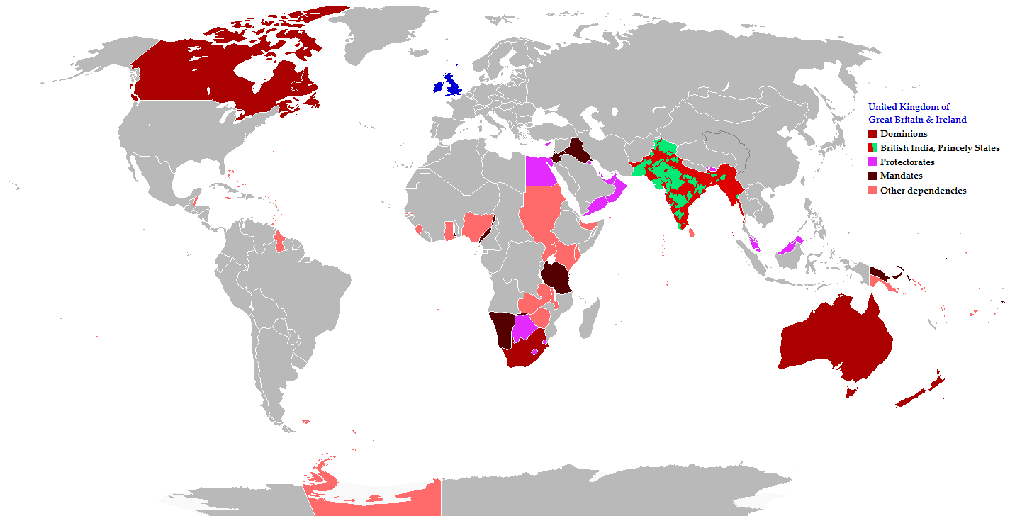
English: Map of the British Empire in 1919 showing all the territories, including the dominions, colonies, protectorates and mandates, ruled or administered by the United Kingdom and its successor states during that year.
Français : Carte de l'Empire britannique en 1919 illustrant tous les territoires, tels que les dominions, colonies, protectorats et mandats, gouvernés ou administrés par le Royaume-Uni ou ses États successeurs cette année-là.
Español: Un mapa de todas las afirmaciones oficiales territorial del Imperio Británico que se celebró en 1919 que identifica qué tipo de celebración estaba presente en todas las posesiones durante ese año.
Deutsch: Eine Karte aller offiziellen territorialen Ansprüche des Britischen Empire, die es im Jahre 1919 hatte, nach Art der Besitzungen in diesem Jahr.
فارسی: نقشه بیمورد از همه ادعاهای ارضی رسمی امپراطوری بریتانیا که در سال 1919 که برای شناسایی نوع برگزاری در حال حاضر تمام اموال در آن سال برگزار شد.
Português: Mapa de todos os territórios reclamados pelo Império Britânico, em 1919, que identifica o tipo de presença britânica no local naquele ano. |
| تاريخ | |
| ذريعو |
The following: |
| ليکڪ | Maps & Lucy |
| اجازت (ھن فائيل کي وَراستعمال ڪندي) |
Released into the public domain (by the author). |
| Other versions | العربيَّة |
Legend
Deutsch (de):
لائيسنسڪاري
This file is licensed under the Creative Commons Attribution-Share Alike 2.5 Generic license.
- توھان آزاد آھيو:
- ونڊڻ لاءِ – اھو ڪم نقل ڪرڻ، ورڇڻ، ۽ پارمڪارڻ
- جڳلبندي ڪرڻ – ڪم اختيار ڪرڻ لاءِ
- ھيٺين شرطن تي:
- انتساب – توهان لازماً مناسب انتساب ڏيو، اجازتنامي ڏانھن ڳنڍڻو مھيا ڪريو، ۽ جيڪڏھن ڪي تبديليون ڪيون ويون ھجن تہ انھن جي نشاندھي ڪريو. توهان اهو ڪري سگهو ٿا ڪنھن بہ معقول طريقي سان، پر ڪنھن بہ اھڙي طريقي سان نہ جيڪو ڏسي تہ اجازتنامو ڏيندڙ توهان جي يا توهان جي استعمال جي توثيق ڪري ٿو.
- ھڪجھڙي ڀاڱيداري – جيڪڏھن توھان ٻيھر ملاوٽ، بدلاءُ، يا مواد تي اڏاوت ڪريو ٿا، توھان کي لازماً پنھنجون ڀاڱيداريون ساڳي يا موافق اجازتنامي جھڙو اصل جو ھيو، ھيٺ ٻيھر-ورھائڻ گهرجن.
فائيل جي سوانح
ڪنھن بہ تاريخ/وقت تي ٽڙڪ ڪري ڏسندا تہ ان وقت اهو فائيل ڪيئن هو.
| تاريخ/وقت | آڱوٺي ننھن | ماپَ | واپرائيندڙ | راءِ | |
|---|---|---|---|---|---|
| موجود نسخو | 08:26, 31 آڪٽوبر 2021 | | 1,425 × 728 (52 KB) | Randomastwritter | jubaland |
| 20:43, 17 نومبر 2014 |  | 1,425 × 728 (61 KB) | GrenaderGD44 | Убраны артефакты с карты в районе Антарктиды | |
| 01:40, 17 نومبر 2014 |  | 1,425 × 728 (65 KB) | GrenaderGD44 | Бутан - протекторат с 1910 года | |
| 18:36, 9 مارچ 2014 |  | 1,425 × 625 (39 KB) | Htonl | Bechuanaland, Basutoland and Swaziland were protectorates | |
| 20:02, 18 جُونِ 2011 |  | 1,425 × 625 (55 KB) | Maps & Lucy | The British Empire, Mongolia and the Soviet Union all recognized Tibet as an independent state and the British Empire via British India were heavily involved in Tibet's independence. | |
| 19:05, 7 مَئي 2011 |  | 1,425 × 625 (58 KB) | Quigley | Correct China's borders closer to what was internationally recognized at the time | |
| 23:55, 15 ڊسمبر 2010 |  | 1,425 × 625 (55 KB) | Maps & Lucy | Added protectorates and Princely States | |
| 22:47, 10 ڊسمبر 2010 |  | 1,425 × 625 (53 KB) | Maps & Lucy | Papua was a colony not a dominion, Gold Coast did not include British Togoland and British Togoland was a mandate. | |
| 18:20, 7 نومبر 2010 |  | 1,425 × 625 (59 KB) | Spesh531 | fix mistake in botswana | |
| 18:19, 7 نومبر 2010 |  | 1,425 × 625 (56 KB) | Spesh531 | really a way to revert. use this version |
ڳنڍڻا
هن فائيل سان هيٺيان صفحا ڳنڍيل آهن.
گلوبل فائيل جو استعمال
ھيٺيون وڪيز بہ ھيءُ فائيل استعمال ڪن ٿيون:
- af.wikipedia.org تي استعمال
- ar.wikipedia.org تي استعمال
- azb.wikipedia.org تي استعمال
- az.wikipedia.org تي استعمال
- ba.wikipedia.org تي استعمال
- be-tarask.wikipedia.org تي استعمال
- be.wikipedia.org تي استعمال
- bg.wikipedia.org تي استعمال
- bs.wikipedia.org تي استعمال
- bxr.wikipedia.org تي استعمال
- cdo.wikipedia.org تي استعمال
- de.wikipedia.org تي استعمال
- el.wikipedia.org تي استعمال
- en.wikipedia.org تي استعمال
- eo.wikipedia.org تي استعمال
- fiu-vro.wikipedia.org تي استعمال
- fi.wikipedia.org تي استعمال
- fr.wikipedia.org تي استعمال
- he.wikipedia.org تي استعمال
- hif.wikipedia.org تي استعمال
- hr.wikipedia.org تي استعمال
- hy.wikipedia.org تي استعمال
- ia.wikipedia.org تي استعمال
- id.wikipedia.org تي استعمال
- is.wikipedia.org تي استعمال
- ja.wikipedia.org تي استعمال
- kk.wikipedia.org تي استعمال
- krc.wikipedia.org تي استعمال
- lez.wikipedia.org تي استعمال
- lo.wikipedia.org تي استعمال
- lv.wikipedia.org تي استعمال
- ms.wikipedia.org تي استعمال
- mwl.wikipedia.org تي استعمال
- my.wikipedia.org تي استعمال
- nl.wikipedia.org تي استعمال
- nn.wikipedia.org تي استعمال
- pnb.wikipedia.org تي استعمال
- qu.wikipedia.org تي استعمال
- ru.wikipedia.org تي استعمال
ھن فائيل جو وڌيڪ گلوبل استعمال ڏسو.