فائل:Arshakuni Armenia 150-en.svg

Size of this PNG preview of this SVG file: 800*470 پڪزلس. ٻيا تحلل:320*188 پڪزلس | 640*376 پڪزلس | 1,024*601 پڪزلس | 1,280*751 پڪزلس | 2,560*1,503 پڪزلس | 2,717*1,595 پڪزلس
اصلوڪو فائيل (ايسويجي فائيل، اٽڪل 2,717 × 1,595 عڪسلون، فائيل سائيز: 850 KB)
تَتُ
| تشريح |
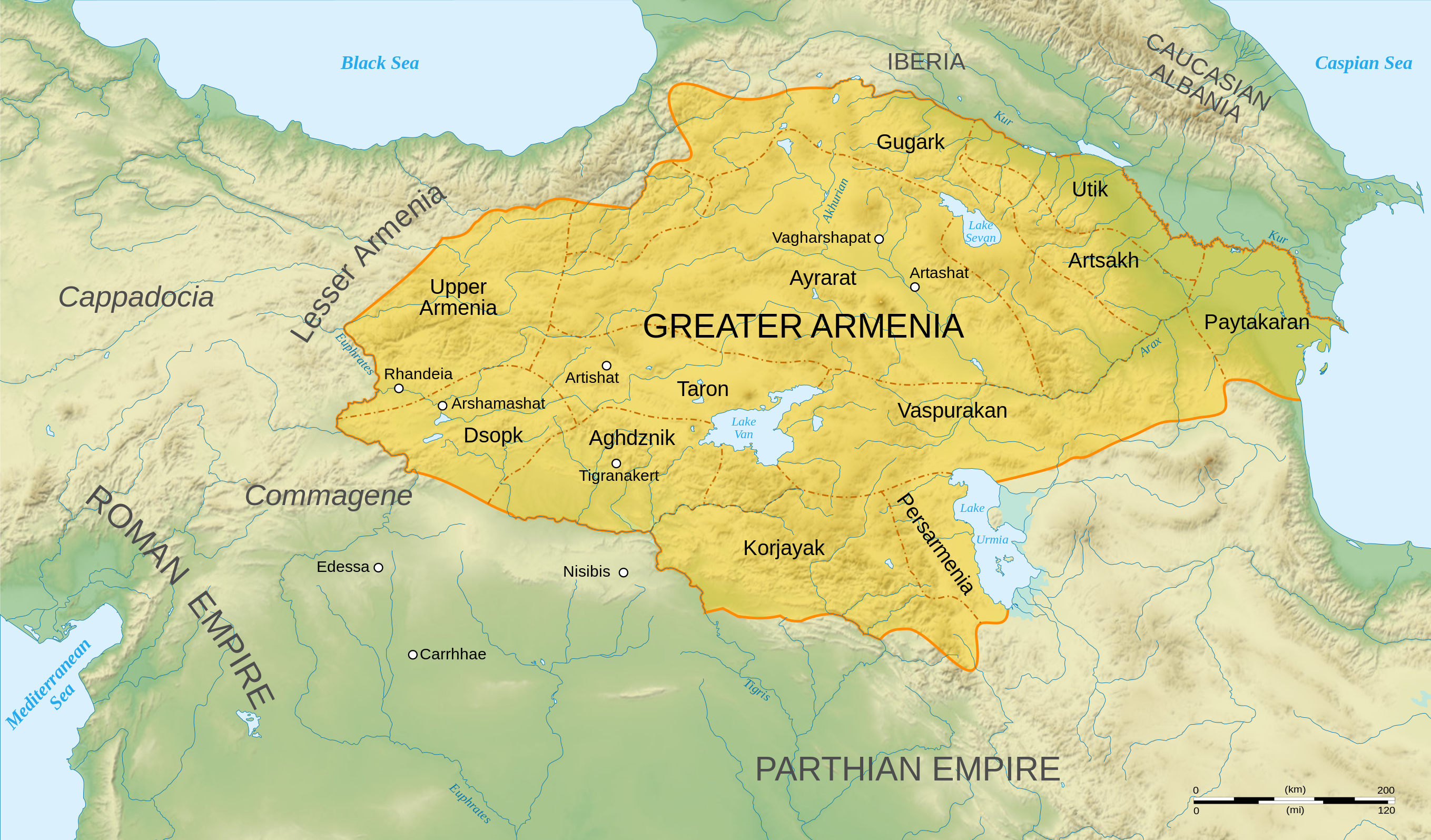
English: Map of Arshakuni Armenia, around the year 150 AD.
Français : Carte en anglais de l'Arménie Arsacide, vers l'an 150. |
||
| تاريخ | |||
| ذريعو |
Own work.
Sources :
Software used :
Autres données :
|
||
| ليکڪ | Sémhur | ||
| Other versions |
[]
| ||
| انتساب (required by the license) | © Sémhur / Wikimedia Commons / | ||
| SVG | W3C-validity not checked.
|
||
| Atelier graphique |


.png)


| Camera location | | View this and other nearby images on: OpenStreetMap |
|---|
لائيسنسڪاري
I, the copyright holder of this work, hereby publish it under the following licenses:
| Copyleft: This work of art is free; you can redistribute it and/or modify it according to terms of the Free Art License. You will find a specimen of this license on the Copyleft Attitude site as well as on other sites. |
This file is licensed under the Creative Commons Attribution-Share Alike 4.0 International, 3.0 Unported, 2.5 Generic, 2.0 Generic and 1.0 Generic license.
- توھان آزاد آھيو:
- ونڊڻ لاءِ – اھو ڪم نقل ڪرڻ، ورڇڻ، ۽ پارمڪارڻ
- جڳلبندي ڪرڻ – ڪم اختيار ڪرڻ لاءِ
- ھيٺين شرطن تي:
- انتساب – توهان لازماً مناسب انتساب ڏيو، اجازتنامي ڏانھن ڳنڍڻو مھيا ڪريو، ۽ جيڪڏھن ڪي تبديليون ڪيون ويون ھجن تہ انھن جي نشاندھي ڪريو. توهان اهو ڪري سگهو ٿا ڪنھن بہ معقول طريقي سان، پر ڪنھن بہ اھڙي طريقي سان نہ جيڪو ڏسي تہ اجازتنامو ڏيندڙ توهان جي يا توهان جي استعمال جي توثيق ڪري ٿو.
- ھڪجھڙي ڀاڱيداري – جيڪڏھن توھان ٻيھر ملاوٽ، بدلاءُ، يا مواد تي اڏاوت ڪريو ٿا، توھان کي لازماً پنھنجون ڀاڱيداريون ساڳي يا موافق اجازتنامي جھڙو اصل جو ھيو، ھيٺ ٻيھر-ورھائڻ گهرجن.
توھان پنھنجي پسند جو اجازتنامو چونڊي سگهو ٿا.
فائيل جي سوانح
ڪنھن بہ تاريخ/وقت تي ٽڙڪ ڪري ڏسندا تہ ان وقت اهو فائيل ڪيئن هو.
| تاريخ/وقت | آڱوٺي ننھن | ماپَ | واپرائيندڙ | راءِ | |
|---|---|---|---|---|---|
| موجود نسخو | 04:22, 30 جُونِ 2023 | | 2,717 × 1,595 (850 KB) | Luckie Luke | File uploaded using svgtranslate tool (https://svgtranslate.toolforge.org/). Added translation for fa. |
| 01:54, 30 جُونِ 2023 |  | 2,717 × 1,595 (808 KB) | Luckie Luke | File uploaded using svgtranslate tool (https://svgtranslate.toolforge.org/). Added translation for fa. | |
| 12:47, 12 جنوري 2008 |  | 2,717 × 1,595 (798 KB) | Sémhur | == Description == {{Information |Description= {{en| Map of Arshakuni Armenia, around the year 150 AD.}} {{fr| Carte en anglais de l'Arménie Arsacide, vers l'an 150.}} |Source=Own work. {{clr}} Sources : * Topographic background : [http://www2.jpl.nasa.go |
ڳنڍڻا
هن فائيل سان هيٺيان صفحا ڳنڍيل آهن.
گلوبل فائيل جو استعمال
ھيٺيون وڪيز بہ ھيءُ فائيل استعمال ڪن ٿيون:
- ar.wikipedia.org تي استعمال
- arz.wikipedia.org تي استعمال
- azb.wikipedia.org تي استعمال
- bg.wikipedia.org تي استعمال
- bn.wikipedia.org تي استعمال
- de.wikipedia.org تي استعمال
- diq.wikipedia.org تي استعمال
- el.wikipedia.org تي استعمال
- Χοσρόης Α΄ της Αρμενίας
- Τιριδάτης Β΄ της Αρμενίας
- Χοσρόης Β΄ της Αρμενίας
- Τιριδάτης Γ΄ της Αρμενίας
- Χοσρόης Γ΄ της Αρμενίας
- Τιράν της Αρμενίας
- Αρσάκης Β΄ της Αρμενίας
- Παπ της Αρμενίας
- Βαρασδάτης της Αρμενίας
- Αρσάκης Γ΄ της Αρμενίας
- Χοσρόης Δ΄ της Αρμενίας
- Βραχμσαπώρ της Αρμενίας
- Αρταξίας Δ΄ της Αρμενίας
- Τιγράνης ΣΤ΄ της Αρμενίας
- Τιριδάτης Α΄ της Αρμενίας
- Βολογέσης Γ΄ της Παρθίας
- Πρότυπο:Δυναστεία των Αρσακιδών της Αρμενίας
- Δυναστεία των Αρσακιδών της Αρμενίας
- Άνω Αρμενία
- Αρζανηνή
- Γογαρινή
- en.wikipedia.org تي استعمال
- en.wiktionary.org تي استعمال
- eo.wikipedia.org تي استعمال
ھن فائيل جو وڌيڪ گلوبل استعمال ڏسو.