فائل:1759 map Holy Land and 12 Tribes.jpg

اصلوڪو فائيل(2,000 × 1,676 عڪسلون، فائيل سائيز: 1.74 MB، MIME ٽائيپ: image/jpeg)

ھي فائيل وڪيميڊيا العام مان آھي ۽ ٻين رٿائن پاران پڻ استعمال ٿي سگهي ٿو. تشريح انجي [فائيل جي تشريحي صفحي] ھيٺان ڏنل آھي.

تَتُ

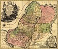
Tobias Conrad Lotter: Latina: Terra Sancta sive Palæstina exhibens no ſolum Regna vetera Iuda et Israel in ſuas XII Tribus diſtincta, ſed etiam eorundem diverſarum ætatum conditionem et facta in Sacris Paginis indicata.   (Wikidata search (Cirrus search) Wikidata query (SPARQL)  Create new Wikidata item based on this file)
Artist
Tobias Conrad Lotter  (1717–1777)  wikidata:Q106511
 
متبادل نالا
Lotter, Tobias Conrad / Lotter, Tobias Konrad
Description copper engraver، cartographer ۽ publisher
Date of birth/death 1717 Edit this at Wikidata 1777 Edit this at Wikidata
Location of birth/death Augsburg Augsburg
Work location
اختياري ڪنٽرول
artist QS:P170,Q106511
Title
Latina: Terra Sancta sive Palæstina exhibens no ſolum Regna vetera Iuda et Israel in ſuas XII Tribus diſtincta, ſed etiam eorundem diverſarum ætatum conditionem et facta in Sacris Paginis indicata.
تشريح
English: English Translation: The Holy Land or Palestine showing not only the Old Kingdoms of Judea and Israel but also the 12 Tribes Distinctly, Confirming their Locations Diversely in their Ancient Condition and Doing So as the Holy Scriptures Indicate.
تاريخ 1759
date QS:P571,+1759-00-00T00:00:00Z/9
Medium hand-colored
Dimensions height: ٤٧٫٠ cm؛ width: ٥٧٫٠ cm
dimensions QS:P2048,47U174728
dimensions QS:P2049,57U174728
Library of Congress Geography and Map Division Washington, D.C. 20540-4650
نوٽس Scale [ca. 1:695,000]
Source/Photographer Geography and Map Division, Library of Congress
Other versions

لائيسنسڪاري

This is a faithful photographic reproduction of a two-dimensional, public domain work of art. The work of art itself is in the public domain for the following reason:
Public domain

This work is in the public domain in its country of origin and other countries and areas where the copyright term is the author's life plus 100 years or fewer.


You must also include a United States public domain tag to indicate why this work is in the public domain in the United States.
The official position taken by the Wikimedia Foundation is that "faithful reproductions of two-dimensional public domain works of art are public domain".
This photographic reproduction is therefore also considered to be in the public domain in the United States. In other jurisdictions, re-use of this content may be restricted; see Reuse of PD-Art photographs for details.

عنوان

ھڪ-سٽي وضاحت ڏيو تہ ھي فائيل ڇاکي ٿو ظاھر ڪري

Items portrayed in this file

depicts انگريزي

MIME type انگريزي

image/jpeg

checksum انگريزي

9aec441e2a748bb1f14eca6e42dd7d08ce2e766b

determination method انگريزي: SHA-1 انگريزي

data size انگريزي

1827878 byte

height انگريزي

1676 عَڪسِل

width انگريزي

2000 عَڪسِل

فائيل جي سوانح

ڪنھن بہ تاريخ/وقت تي ٽڙڪ ڪري ڏسندا تہ ان وقت اهو فائيل ڪيئن هو.

تاريخ/وقتآڱوٺي ننھنماپَواپرائيندڙراءِ
موجود نسخو10:43, 12 سيپٽمبر 200510:43, 12 سيپٽمبر 2005 جي نظرثاني لاءِ تصويري نشان2,000 × 1,676 (1.74 MB)Humus sapiens~commonswiki1759 map: Terra Sancta sive Palæstina exhibens no folum Regna vetera Iuda et Israel in fuas XII Tribus diftincta... Source: Library of Congress historical maps Category:Historical maps of the Middle East Category:Israel

هن فائيل سان هيٺيان صفحا ڳنڍيل آهن.

گلوبل فائيل جو استعمال

ھيٺيون وڪيز بہ ھيءُ فائيل استعمال ڪن ٿيون:

ھن فائيل جو وڌيڪ گلوبل استعمال ڏسو.