فائل:Districts of Khyber Pakhtunkhwa, Pakistan.png

هن پيش-نگاھ جي ماپ: 600*600 پڪزلس. ٻيا تحلل:240*240 پڪزلس | 480*480 پڪزلس | 768*768 پڪزلس | 1,024*1,024 پڪزلس | 2,048*2,048 پڪزلس | 3,840*3,840 پڪزلس
اصلوڪو فائيل (3,840 × 3,840 عڪسلون، فائيل سائيز: 1.45 MB، MIME ٽائيپ: image/png)
This file supersedes the file Khyber Pakhtunkhwa, KPK, Map.png. It is recommended to use this file rather than the other one. Reason why to use this file over the other file: "More up-to-date map and fixed borders."
|

|
تَتُ
| تشريح |
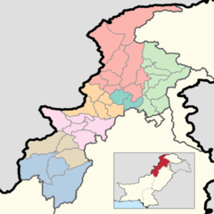
English: This is a map showing each and every district of Khyber Pakhtunkhwa. The map is accurate as of September 30, 2020 and has been made using data from the Pakistan Bureau of Statistics and UN OCHA's HumData Database (which citypopulation.de uses). Each color depicts a different administrative division (higher than a district but lower than a province).
A category full of these maps listed nicely can be found here. |
| تاريخ | |
| ذريعو | ڪم پنھنجايو |
| ليکڪ | User:Abbasi786786 |
لائيسنسڪاري
I, the copyright holder of this work, hereby publish it under the following license:
This file is licensed under the Creative Commons Attribution-Share Alike 4.0 International license.
- توھان آزاد آھيو:
- ونڊڻ لاءِ – اھو ڪم نقل ڪرڻ، ورڇڻ، ۽ پارمڪارڻ
- جڳلبندي ڪرڻ – ڪم اختيار ڪرڻ لاءِ
- ھيٺين شرطن تي:
- انتساب – توهان لازماً مناسب انتساب ڏيو، اجازتنامي ڏانھن ڳنڍڻو مھيا ڪريو، ۽ جيڪڏھن ڪي تبديليون ڪيون ويون ھجن تہ انھن جي نشاندھي ڪريو. توهان اهو ڪري سگهو ٿا ڪنھن بہ معقول طريقي سان، پر ڪنھن بہ اھڙي طريقي سان نہ جيڪو ڏسي تہ اجازتنامو ڏيندڙ توهان جي يا توهان جي استعمال جي توثيق ڪري ٿو.
- ھڪجھڙي ڀاڱيداري – جيڪڏھن توھان ٻيھر ملاوٽ، بدلاءُ، يا مواد تي اڏاوت ڪريو ٿا، توھان کي لازماً پنھنجون ڀاڱيداريون ساڳي يا موافق اجازتنامي جھڙو اصل جو ھيو، ھيٺ ٻيھر-ورھائڻ گهرجن.
فائيل جي سوانح
ڪنھن بہ تاريخ/وقت تي ٽڙڪ ڪري ڏسندا تہ ان وقت اهو فائيل ڪيئن هو.
| تاريخ/وقت | آڱوٺي ننھن | ماپَ | واپرائيندڙ | راءِ | |
|---|---|---|---|---|---|
| موجود نسخو | 14:42, 16 جُونِ 2020 | | 3,840 × 3,840 (1.45 MB) | Abbasi786786 | Added a box in the bottom right corner to signify where Khyber Pakhtunkhwa Province is in Pakistan. |
| 17:09, 15 جُونِ 2020 |  | 3,840 × 3,840 (1.31 MB) | Abbasi786786 | Uploaded own work with UploadWizard |
ڳنڍڻا
هن فائيل سان هيٺيان صفحا ڳنڍيل آهن.
گلوبل فائيل جو استعمال
ھيٺيون وڪيز بہ ھيءُ فائيل استعمال ڪن ٿيون:
- bn.wikipedia.org تي استعمال
- de.wikipedia.org تي استعمال
- en.wikipedia.org تي استعمال
- pnb.wikipedia.org تي استعمال